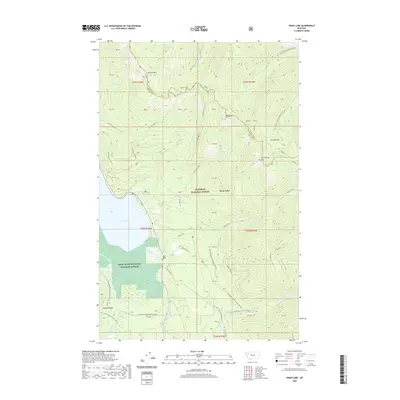
2020 Map of Swan Lake
USGS Topo · Published 2020About this map
Swan River National Wildlife Refuge occupies the southern valley floor on this 2020 survey, where the river feeds into the southern tip of Swan Lake. This corridor, flanked by the Mission Range to the west and the Swan Range to the east, is heavily defined by federal land management within the Flathead National Forest. The map documents a complex network of forest development roads and specialized recreation routes, including the Crane Mtn Snowmobile area and numerous named paths like the Hall Lake Trail and the Bond Creek Trl.
Find a feature on this map
47 named features on this map. Tap any name to fly to it.
Don’t see what you’re looking for? This feature index may not catch every label — zoom into the map to look around manually.
Map Details
Editions of this 2020 Swan Lake Map
This is the sole edition of this map. No revisions or reprints were ever made.
Other maps of this area

1914 · Nyack
USGS Topo · 1:125,000

1955 · Choteau
USGS Topo · 1:250,000

1957 · Choteau
USGS Topo · 1:250,000

1958 · Choteau
USGS Topo · 1:250,000

1958 · Quintonkon
USGS Topo · 1:24,000

1960 · Cut Bank
USGS Topo · 1:250,000

1962 · Choteau
USGS Topo · 1:250,000

1963 · Cut Bank
USGS Topo · 1:250,000

1964 · Cut Bank
USGS Topo · 1:250,000
1964 · Crater Lake
USGS Topo · 1:24,000