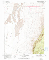
1972 Map of Swasey Peak SW
USGS Topo · Published 1991About this map
The Tule Valley (Depression) dominates this corner of Millard County, representing a vast, arid basin defined by its stark geological boundaries. Along the western edge, the Smelter Hills rise above the valley floor, while the eastern portion is anchored by the prominent elevations of the Middle Range. The landscape between these features is characterized by shifting Sand Dunes, illustrating the wind-driven environmental processes of the Great Basin during the early 1970s. This survey records a largely undeveloped area where human activity is limited to a solitary Well and established survey benchmarks like BM 4491, marking the essential infrastructure for monitoring this remote high-desert terrain before modern expansion.
Find a feature on this map
11 named features on this map. Tap any name to fly to it.
Don’t see what you’re looking for? This feature index may not catch every label — zoom into the map to look around manually.
Map Details
Editions of this 1972 Swasey Peak SW Map
2 editions found
Other maps of this area

1908 · Fish Springs
USGS Topo · 1:250,000

1910 · Fish Springs
USGS Topo · 1:250,000

1953 · Delta
USGS Topo · 1:250,000

1958 · Delta
USGS Topo · 1:250,000

1959 · Cowboy Pass
USGS Topo · 1:62,500

1960 · Notch Peak
USGS Topo · 1:62,500

1960 · Conger Mountain
USGS Topo · 1:62,500

1962 · Delta
USGS Topo · 1:250,000

1972 · Swasey Peak SW
USGS Topo · 1:24,000
1972 · Swasey Peak
USGS Topo · 1:24,000