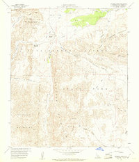
1959 Map of Sweeney Pass
USGS Topo · Published 1960About this map
The Anza-Borrego Desert State Park dominates this desert landscape, where historical travel routes intersect with severe geological formations. The Old Overland Stage Route skirts the northern edge of the Carrizo Badlands, tracing a path used by early pioneers through the Carrizo Valley. Further south, the engineering of the San Diego and Arizona Eastern railroad winds through the complex topography of the Jacumba Mountains and In-Ko-Pah Mountains, passing near Dos Cabezas.
Find a feature on this map
32 named features on this map. Tap any name to fly to it.
Don’t see what you’re looking for? This feature index may not catch every label — zoom into the map to look around manually.
Map Details
Editions of this 1959 Sweeney Pass Map
4 editions found
Other maps of this area

1931 · Carrizo
USGS Topo · 1:125,000

1939 · Campo
USGS Topo · 1:62,500

1939 · Jacumba
USGS Topo · 1:62,500

1942 · Campo
USGS Topo · 1:62,500

1942 · Carrizo Mtn
USGS Topo · 1:62,500

1942 · Jacumba
USGS Topo · 1:62,500

1942 · Cuyapaipe
USGS Topo · 1:62,500

1950 · San Diego
USGS Topo · 1:250,000

1954 · San Diego
USGS Topo · 1:250,000

1955 · San Diego
USGS Topo · 1:250,000