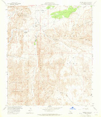
1959 Map of Sweeney Pass
USGS Topo · Published 1965About this map
The Mountain Palm Springs Area serves as a botanical focal point in this 1959 survey of the California desert, featuring a series of named groves such as Marys Grove, Pygmy Grove, and Southwest Grove. This portion of Anza-Borrego Desert State Park reveals a landscape defined by the intersection of the Jacumba Mountains and the In-Ko-Pah Mountains. The topography is marked by significant elevation changes at Sweeney Pass and the erosion patterns of the Carrizo Badlands.
Find a feature on this map
45 named features on this map. Tap any name to fly to it.
Don’t see what you’re looking for? This feature index may not catch every label — zoom into the map to look around manually.
Map Details
Editions of this 1959 Sweeney Pass Map
4 editions found
Other maps of this area

1931 · Carrizo
USGS Topo · 1:125,000

1939 · Campo
USGS Topo · 1:62,500

1939 · Jacumba
USGS Topo · 1:62,500

1942 · Campo
USGS Topo · 1:62,500

1942 · Carrizo Mtn
USGS Topo · 1:62,500

1942 · Jacumba
USGS Topo · 1:62,500

1942 · Cuyapaipe
USGS Topo · 1:62,500

1950 · San Diego
USGS Topo · 1:250,000

1954 · San Diego
USGS Topo · 1:250,000

1955 · San Diego
USGS Topo · 1:250,000