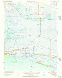
1955 Map of Sweet Lake
USGS Topo · Published 1956About this map
Sweet Lake and the coastal marshlands of Cameron Parish dominate this mid-century landscape, where human settlement clings to the narrow east-west elevations of the Front Ridge and Oak Grove Ridge. These ridges support the community centers of Creole and Oak Grove, connected by a network of schools and churches including Creole High Sch, Cameron High Sch, and Ebenezer Ch. The map illustrates a transitional period for the Gulf coast economy, where the industrial presence of the Sweet Lake Oil Field and numerous pipelines contrast with the traditional reliance on the waterways. Transport is facilitated by the Intracoastal Waterway and the Creole Ferry, while much of the western portion is dedicated to the Sabine National Wildlife Refuge. The detailed mapping of various "cheniers" or ridges like Pumpkin Ridge and Little Cheniere Ridge reveals the historical importance of these high grounds for habitation in an otherwise saturated environment.
Find a feature on this map
60 named features on this map. Tap any name to fly to it.
Don’t see what you’re looking for? This feature index may not catch every label — zoom into the map to look around manually.
Map Details
Editions of this 1955 Sweet Lake Map
4 editions found
Other maps of this area

1932 · Moss Lake
USGS Topo · 1:31,680

1932 · Lake Charles SW
USGS Topo · 1:31,680

1932 · Lake Charles SE
USGS Topo · 1:31,680

1934 · Cameron
USGS Topo · 1:24,000

1934 · Lake Misere
USGS Topo · 1:24,000

1934 · Sweet Lake
USGS Topo · 1:24,000

1934 · Grand Bayou
USGS Topo · 1:24,000

1934 · Boudreaux Lake
USGS Topo · 1:24,000

1935 · Cameron
USGS Topo · 1:31,680

1935 · Sweet Lake
USGS Topo · 1:31,680