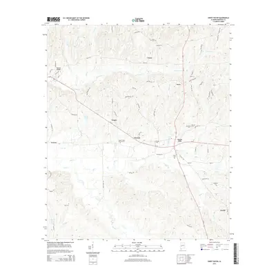
2014 Map of Sweet Water
USGS Topo · Published 2014About this map
Sweet Water and Dixons Mills anchor this Marengo County landscape, where the drainage of Sweetwater Cr and Mill Cr shapes the settlement pattern. The terrain is a network of small watercourses like Sheep Br, Cane Cr, and Horse Cr that carve through the Alabama countryside. This map reveals a high density of rural burial sites, including Union Grove Cem, Dunning Cem, and Pearson Cem, which serve as vital markers for local genealogical research. Small crossroads and hamlets such as Wayne, Vangale, and Marengo are connected by a web of local routes including Al-10 and Wayne Rd. The southern reach of the quadrangle shows the vicinity of Clayhill and Exmoor, highlighting the dispersed nature of these historic agricultural communities.
Find a feature on this map
52 named features on this map. Tap any name to fly to it.
Don’t see what you’re looking for? This feature index may not catch every label — zoom into the map to look around manually.
Map Details
Editions of this 2014 Sweet Water Map
This is the sole edition of this map. No revisions or reprints were ever made.
Other maps of this area

1953 · Montgomery
USGS Topo · 1:250,000

1953 · Andalusia
USGS Topo · 1:250,000

1956 · Montgomery
USGS Topo · 1:250,000

1957 · Montgomery
USGS Topo · 1:250,000

1957 · Andalusia
USGS Topo · 1:250,000

1973 · Thomasville
USGS Topo · 1:24,000

1978 · Surginer
USGS Topo · 1:24,000

1978 · Sweet Water
USGS Topo · 1:24,000
1978 · Bashi
USGS Topo · 1:24,000
1978 · Nanafalia
USGS Topo · 1:24,000