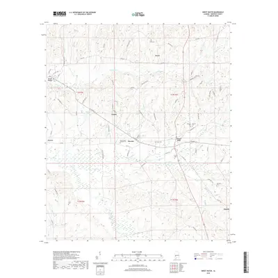
2018 Map of Sweet Water
USGS Topo · Published 2018About this map
Sweet Water and Dixons Mills anchor this portion of Marengo County, where the landscape is defined by the winding course of Sweetwater Cr and its numerous tributaries. The map documents a rural Alabama community structured by family and congregational landmarks, including several burial grounds such as Pearson Cem, Union Grove Cem, and Morrissette Cem. These sites, alongside Paynes Chapel Methodist Cem, provide essential anchor points for genealogists and local historians tracing the area's settlement patterns.
Find a feature on this map
80 named features on this map. Tap any name to fly to it.
Don’t see what you’re looking for? This feature index may not catch every label — zoom into the map to look around manually.
Map Details
Editions of this 2018 Sweet Water Map
This is the sole edition of this map. No revisions or reprints were ever made.
Other maps of this area

1953 · Montgomery
USGS Topo · 1:250,000

1953 · Andalusia
USGS Topo · 1:250,000

1956 · Montgomery
USGS Topo · 1:250,000

1957 · Montgomery
USGS Topo · 1:250,000

1957 · Andalusia
USGS Topo · 1:250,000

1973 · Thomasville
USGS Topo · 1:24,000

1978 · Surginer
USGS Topo · 1:24,000

1978 · Sweet Water
USGS Topo · 1:24,000
1978 · Bashi
USGS Topo · 1:24,000
1978 · Nanafalia
USGS Topo · 1:24,000