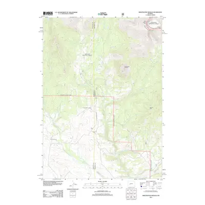
2012 Map of Sweetwater Needles
USGS Topo · Published 2012About this map
Sweetwater River and Little Sweetwater River define the drainage patterns of this high-elevation landscape in Fremont County. The map documents a sparsely populated ranching territory characterized by the Sweetwater Gap Ranch and White Acorn Ranch, which are connected by Sweetwater Gap Rd. This region serves as a vital watershed, where numerous seasonal and perennial streams like Larsen Cr, Station Cr, and Blucher Cr flow from the surrounding peaks.
Find a feature on this map
18 named features on this map. Tap any name to fly to it.
Don’t see what you’re looking for? This feature index may not catch every label — zoom into the map to look around manually.
Map Details
Editions of this 2012 Sweetwater Needles Map
This is the sole edition of this map. No revisions or reprints were ever made.
Other maps of this area

1953 · Sweetwater Gap
USGS Topo · 1:24,000

1953 · Cony Mountain
USGS Topo · 1:24,000

1953 · Christina Lake
USGS Topo · 1:24,000

1955 · Lander
USGS Topo · 1:250,000

1958 · Lander
USGS Topo · 1:250,000

1958 · Parting of the Ways
USGS Topo · 1:62,500

1961 · Lander
USGS Topo · 1:250,000

1969 · Jensen Meadows
USGS Topo · 1:24,000
1969 · Sweetwater Needles
USGS Topo · 1:24,000
1969 · Temple Peak
USGS Topo · 1:24,000