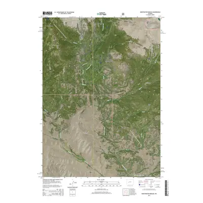
2015 Map of Sweetwater Needles
USGS Topo · Published 2015About this map
The Continental Divide runs through this high-altitude landscape in the Wind River Range, marking the border between the Shoshone National Forest and the Bridger National Forest. This section of the Wyoming wilderness is defined by its dramatic peaks and water systems, where the headwaters of the Sweetwater River and the Little Sweetwater River emerge from the high country. The map traces the Continental Divide National Scenic Trail as it winds across alpine passes such as Christina Pass and through the Sweetwater Gap. Named landmarks like the Sweetwater Needles, Atlantic Peak, and Wildcat Butte provide orientation for those navigating this complex terrain. The presence of the Sweetwater Gap Rd and numerous drainages like Blair Creek and Mill Creek illustrates the intricate hydrology of the Fremont and Sublette County line.
Find a feature on this map
30 named features on this map. Tap any name to fly to it.
Don’t see what you’re looking for? This feature index may not catch every label — zoom into the map to look around manually.
Map Details
Editions of this 2015 Sweetwater Needles Map
This is the sole edition of this map. No revisions or reprints were ever made.
Other maps of this area

1953 · Sweetwater Gap
USGS Topo · 1:24,000

1953 · Cony Mountain
USGS Topo · 1:24,000

1953 · Christina Lake
USGS Topo · 1:24,000

1955 · Lander
USGS Topo · 1:250,000

1958 · Lander
USGS Topo · 1:250,000

1958 · Parting of the Ways
USGS Topo · 1:62,500

1961 · Lander
USGS Topo · 1:250,000

1969 · Jensen Meadows
USGS Topo · 1:24,000
1969 · Sweetwater Needles
USGS Topo · 1:24,000
1969 · Temple Peak
USGS Topo · 1:24,000