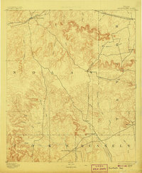
1893 Map of Sweetwater
USGS Topo · Published 1907About this map
Sweetwater serves as the focal point of this late nineteenth-century reconnaissance, situated at the intersection of early West Texas cattle country and the expanding Texas and Pacific Railway. The landscape transitions from the rail-oriented settlements of Trent and Merkel in the north toward the military and frontier history of Fort Chadbourne at the southern boundary. This 1891 survey, conducted under J.W. Powell, illustrates a region defined by its hydrology and high points, where travelers relied on landmarks like Castle Peak and Mountain Pass to navigate between the drainage of Sweetwater Creek and Mulberry Canyon. Small, dispersed communities such as Hylton, Dora, and Nubia appear as early outposts in Nolan and Taylor counties, linked by a network of creeks including Antelope Creek and Cottonwood Creek that dictated the placement of ranching and early commerce.
Find a feature on this map
36 named features on this map. Tap any name to fly to it.
Don’t see what you’re looking for? This feature index may not catch every label — zoom into the map to look around manually.
Map Details
Editions of this 1893 Sweetwater Map
4 editions found
Other maps of this area

1890 · Abilene
USGS Topo · 1:125,000

1891 · Hayrick
USGS Topo · 1:125,000

1891 · Anson
USGS Topo · 1:125,000

1892 · Abilene
USGS Topo · 1:125,000

1892 · Ballinger
USGS Topo · 1:125,000

1893 · Roby
USGS Topo · 1:125,000

1893 · Anson
USGS Topo · 1:125,000

1893 · Sweetwater
USGS Topo · 1:125,000

1894 · Hayrick
USGS Topo · 1:125,000

1921 · Bronte
USGS Topo · 1:31,680