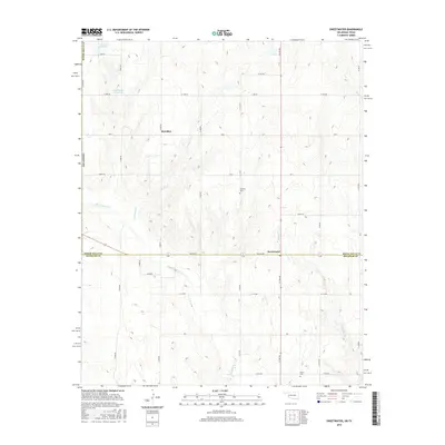
2016 Map of Sweetwater
USGS Topo · Published 2016About this map
Sweetwater sits along the border of Beckham and Roger Mills counties, anchored by a network of rural roads such as ew110 RD and N 1720 RD. The landscape is defined by the winding paths of Sweetwater Cr and W Buffalo Cr, which drain the rolling agricultural terrain of western Oklahoma. Local history is preserved at sites like Mulberry Cem and Salem Cem, which serve as genealogical markers for the surrounding farming community. To the north, the small settlement of Meridian is situated near the Oklahoma-Texas state line, while water resources like Davis Reservoir and Davis Number 2 Reservoir highlight the importance of land management in this prairie region. This 2016 survey provides a clear view of the modern rural infrastructure, showing how transportation routes like Oklahoma Highway 152 continue to connect these persistent high-plains settlements.
Find a feature on this map
35 named features on this map. Tap any name to fly to it.
Don’t see what you’re looking for? This feature index may not catch every label — zoom into the map to look around manually.
Map Details
Editions of this 2016 Sweetwater Map
This is the sole edition of this map. No revisions or reprints were ever made.
Other maps of this area

1954 · Amarillo
USGS Topo · 1:250,000

1955 · Clinton
USGS Topo · 1:250,000

1957 · Clinton
USGS Topo · 1:250,000

1958 · Amarillo
USGS Topo · 1:250,000

1960 · Sweetwater
USGS Topo · 1:62,500

1961 · Reydon
USGS Topo · 1:62,500

1962 · Kelton SE
USGS Topo · 1:24,000

1963 · Allison
USGS Topo · 1:24,000

1963 · Kelton
USGS Topo · 1:24,000
1982 · Pampa
USGS Topo · 1:100,000