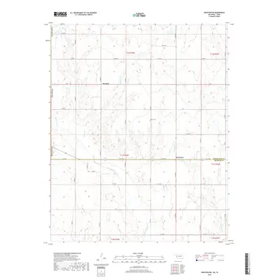
2018 Map of Sweetwater
USGS Topo · Published 2018About this map
The community of Sweetwater lies at the intersection of the Roger Mills and Beckham Co line in western Oklahoma. This 2018 survey illustrates a rural landscape defined by the drainage systems of Sweetwater Creek and West Buffalo Creek, which feed into a series of intermittent streams like Freezeout Creek. To the north, the small settlement of Meridian is situated near the state border, anchored by a network of sectional roads such as RM D and East 1060 Road.
Find a feature on this map
29 named features on this map. Tap any name to fly to it.
Don’t see what you’re looking for? This feature index may not catch every label — zoom into the map to look around manually.
Map Details
Editions of this 2018 Sweetwater Map
This is the sole edition of this map. No revisions or reprints were ever made.
Other maps of this area

1954 · Amarillo
USGS Topo · 1:250,000

1955 · Clinton
USGS Topo · 1:250,000

1957 · Clinton
USGS Topo · 1:250,000

1958 · Amarillo
USGS Topo · 1:250,000

1960 · Sweetwater
USGS Topo · 1:62,500

1961 · Reydon
USGS Topo · 1:62,500

1962 · Kelton SE
USGS Topo · 1:24,000

1963 · Allison
USGS Topo · 1:24,000

1963 · Kelton
USGS Topo · 1:24,000
1982 · Pampa
USGS Topo · 1:100,000