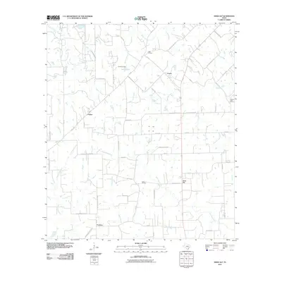
2010 Map of Swiss Alp
USGS Topo · Published 2010About this map
Swiss Alp and the surrounding Fayette County countryside are defined by a network of creeks and small settlements in this 2010 survey. The landscape is a transition between the West Navidad River and East Navidad River, which converge south of the quadrangle. Several distinct rural communities including Hostyn, O'Quinn, and Freyburg serve as local hubs for the surrounding farm and ranch land. Genealogical interest is centered on well-placed sites such as Cedar Cemetery, Kaase Cemetery, and Williams Creek Cemetery, often located near prominent water features like Creamer Creek and Williams Creek. The introduction of Lake El-Leo and its corresponding Lake El-Leo Dam north of Hostyn represents a significant modern water management feature in an area otherwise characterized by natural drainages like Buckners Creek and Walker Branch.
Find a feature on this map
57 named features on this map. Tap any name to fly to it.
Don’t see what you’re looking for? This feature index may not catch every label — zoom into the map to look around manually.
Map Details
Editions of this 2010 Swiss Alp Map
This is the sole edition of this map. No revisions or reprints were ever made.
Other maps of this area

1901 · Flatonia
USGS Topo · 1:125,000

1919 · Schulenburg
USGS Topo · 1:62,500

1953 · Seguin
USGS Topo · 1:250,000

1956 · La Grange
USGS Topo · 1:62,500

1957 · La Grange East
USGS Topo · 1:24,000

1957 · Ammannsville
USGS Topo · 1:24,000

1958 · La Grange West
USGS Topo · 1:24,000
1958 · West Point
USGS Topo · 1:24,000

1958 · Seguin
USGS Topo · 1:250,000

1965 · Muldoon
USGS Topo · 1:24,000