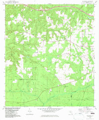
1982 Map of Sycamore
USGS Topo · Published 1983About this map
The community of Sycamore and the surrounding pine-clad terrain of Gadsden and Liberty counties are meticulously documented in this early 1980s revision. The landscape is defined by its deep spiritual and ancestral roots, shown through a dense network of country churches and family burial grounds like Smith Cem and Gause Cem. The presence of the Forbes Purchase Line in the southern portion of the sheet references one of Florida's most significant colonial-era land grants, still influencing property boundaries today. Beyond the scattered farmsteads, the map records a local economy tied to the land, from the Claypit and Sandpit operations to the various branches of the Telogia Creek system. The area around Juniper and the Greensboro Sch highlights the distribution of rural civic life in the Florida panhandle during this period.
Find a feature on this map
37 named features on this map. Tap any name to fly to it.
Don’t see what you’re looking for? This feature index may not catch every label — zoom into the map to look around manually.
Map Details
Editions of this 1982 Sycamore Map
This is the sole edition of this map. No revisions or reprints were ever made.
Other maps of this area

1943 · Lake Talquin
USGS Topo · 1:62,500

1945 · Hosford
USGS Topo · 1:31,680

1945 · Bristol
USGS Topo · 1:31,680

1954 · Sneads
USGS Topo · 1:24,000

1954 · Tallahassee
USGS Topo · 1:250,000

1955 · Rock Bluff
USGS Topo · 1:24,000

1955 · Sycamore
USGS Topo · 1:24,000

1955 · Chattahoochee
USGS Topo · 1:24,000

1955 · Mt Pleasant
USGS Topo · 1:24,000

1959 · Tallahassee
USGS Topo · 1:250,000