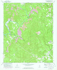
1971 Map of Sylvan Springs
USGS Topo · Published 1978About this map
Locust Fork winds through this Jefferson County landscape, serving as a primary corridor for industry and transport. The river's importance is marked by river mile indicators like Mile 400 and infrastructure such as the Atwood Ferry Bridge and Woodruff Bridge. Along its banks and the neighboring Village Creek, extensive Strip Mine operations appear, highlighting the region's reliance on coal extraction during the mid-20th century.
Find a feature on this map
41 named features on this map. Tap any name to fly to it.
Don’t see what you’re looking for? This feature index may not catch every label — zoom into the map to look around manually.
Map Details
Editions of this 1971 Sylvan Springs Map
3 editions found
Other maps of this area

1889 · Birmingham
USGS Topo · 1:125,000

1890 · Bessemer
USGS Topo · 1:125,000

1892 · Birmingham
USGS Topo · 1:125,000

1892 · Bessemer
USGS Topo · 1:125,000

1893 · Jasper
USGS Topo · 1:125,000

1895 · Birmingham
USGS Topo · 1:125,000

1899 · Brookwood
USGS Topo · 1:125,000

1904 · Birmingham Coal District
USGS Topo · 1:62,500

1905 · Bessemer Iron District
USGS Topo · 1:62,500

1906 · Birmingham Special
USGS Topo · 1:62,500