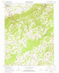
1965 Map of Sylvatus
USGS Topo · Published 1978About this map
The Old Shot Tower and Shot Tower State Historical Park overlook the New River in the northwest corner of this map, marking a site of early industrial significance where lead shot was once manufactured near Jackson Ferry. The landscape is dominated by the ridges of Poplar Camp Mountain, with numerous small communities and family-named landmarks scattered through the valleys of Little Reed Island Creek and Shorts Creek. Settlement patterns are defined by a network of rural churches and schools, such as Round Knob Ch, Corinth Ch, and the Laurel Sch. Genealogists may find interest in the Beasley Hill Cem and other burial sites that dot the countryside. Transportation infrastructure by the mid-1960s includes the Norfolk and Western railroad and the Twin County Airport, while purple photorevisions from the late 1970s show a major highway under construction across the southern half of the quadrangle.
Find a feature on this map
45 named features on this map. Tap any name to fly to it.
Don’t see what you’re looking for? This feature index may not catch every label — zoom into the map to look around manually.
Map Details
Editions of this 1965 Sylvatus Map
3 editions found
Other maps of this area

1889 · Hillsville
USGS Topo · 1:125,000

1892 · Hillsville
USGS Topo · 1:125,000

1896 · Hillsville
USGS Topo · 1:125,000

1930 · Max Meadows
USGS Topo · 1:62,500

1931 · Galax
USGS Topo · 1:48,000

1933 · Galax
USGS Topo · 1:62,500

1953 · Winston-Salem
USGS Topo · 1:250,000

1955 · Winston-Salem
USGS Topo · 1:250,000

1956 · Macks Mountain
USGS Topo · 1:62,500

1957 · Mount Airy
USGS Topo · 1:62,500