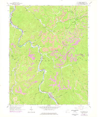
1965 Map of Sylvester
USGS Topo · Published 1977About this map
The Big Coal River snakes through the heart of the Sherman district in Boone County, defining the industrial and social layout of this coal-mining corridor. Following the river's winding path, the Chesapeake and Ohio railroad serves as the primary artery connecting a string of small settlements and mining operations, from Seth and Kirbyton in the north down to Prenter and Sylvester in the south. The hillsides are heavily marked by strip mines, particularly in the Cabin Creek Mines area, where the terrain reflects decades of extraction.
Find a feature on this map
60 named features on this map. Tap any name to fly to it.
Don’t see what you’re looking for? This feature index may not catch every label — zoom into the map to look around manually.
Map Details
Editions of this 1965 Sylvester Map
2 editions found
Other maps of this area

1891 · Oceana
USGS Topo · 1:125,000

1891 · Raleigh
USGS Topo · 1:125,000

1893 · Oceana
USGS Topo · 1:125,000

1897 · Kanawha Falls
USGS Topo · 1:125,000

1897 · Raleigh
USGS Topo · 1:125,000

1898 · Oceana
USGS Topo · 1:125,000

1899 · Charleston
USGS Topo · 1:125,000

1900 · Kanawha Falls
USGS Topo · 1:125,000

1901 · Kanawha Falls
USGS Topo · 1:125,000

1902 · Raleigh
USGS Topo · 1:125,000