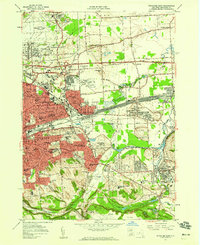
1957 Map of Syracuse East
USGS Topo · Published 1959About this map
The eastern edge of Syracuse and its developing suburbs reflect a period of significant mid-century expansion, marked by the arrival of the New York State Thruway and the industrial activity of the DeWitt Yards. Education and institutional growth are prominent, with the campuses of Syracuse University and Le Moyne College anchoring the urban landscape near the New York Central rail lines. The transition from industrial corridors to residential areas is evident through numerous local institutions like Nottingham High Sch and Jamesville-De Witt Central Sch.
Find a feature on this map
87 named features on this map. Tap any name to fly to it.
Don’t see what you’re looking for? This feature index may not catch every label — zoom into the map to look around manually.
Map Details
Editions of this 1957 Syracuse East Map
4 editions found
Other maps of this area

1895 · Chittenango
USGS Topo · 1:62,500

1895 · Syracuse
USGS Topo · 1:62,500

1897 · Cazenovia
USGS Topo · 1:62,500

1898 · Syracuse
USGS Topo · 1:62,500

1898 · Chittenango
USGS Topo · 1:62,500

1899 · Cazenovia
USGS Topo · 1:62,500

1900 · Tully
USGS Topo · 1:62,500

1902 · Chittenango
USGS Topo · 1:62,500

1938 · Syracuse East
USGS Topo · 1:24,000

1939 · Syracuse West
USGS Topo · 1:24,000