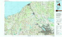
1985 Map of Syracuse
USGS Topo · Published 1994About this map
Syracuse and its surrounding central New York landscape are defined by a complex network of glacial drumlins and historic waterways in this mid-1980s study. The city core is a hub of education and infrastructure, featuring Syracuse University and the Syracuse Hancock International Airport, while the Seneca River and Oswego River systems connect industrial centers like Fulton and Oswego to the Great Lakes. The importance of conservation and managed lands is evident in the sprawling Montezuma National Wildlife Refuge and Montezuma Marsh at the western edge, preserving the unique wetland ecology where the Clyde River meets the Seneca River.
Find a feature on this map
168 named features on this map. Tap any name to fly to it.
Don’t see what you’re looking for? This feature index may not catch every label — zoom into the map to look around manually.
Map Details
Editions of this 1985 Syracuse Map
3 editions found
Other maps of this area

1895 · Chittenango
USGS Topo · 1:62,500

1895 · Pulaski
USGS Topo · 1:62,500

1895 · Syracuse
USGS Topo · 1:62,500

1897 · Cazenovia
USGS Topo · 1:62,500

1898 · Syracuse
USGS Topo · 1:62,500

1898 · Chittenango
USGS Topo · 1:62,500

1899 · Auburn
USGS Topo · 1:62,500

1899 · Skaneateles
USGS Topo · 1:62,500

1899 · Cazenovia
USGS Topo · 1:62,500

1899 · Palmyra
USGS Topo · 1:62,500