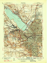
1947 Map of Syracuse West
USGS Topo · Published 1947About this map
Onondaga Lake defines the central geography of this 1940s landscape, where the industrial and municipal growth of Syracuse expands westward toward Solvay. The map illustrates a complex transition of land use, from the dense urban grid of the city to the prominent State Fairgrounds and the historic Fort Ste Marie De Gannentaha. Significant institutional presence is visible on the southern periphery, marked by the County Home, a Sanitarium, and several large cemeteries like Oakwood Cemetery and St Agnes Cem. The transportation network is heavily influenced by the New York Central railroad and the New York State Barge Canal Terminal, reflecting the area's mid-century reliance on rail and water for commerce. Small outlying communities like Lakeland, Fairmount, and Taunton appear as emerging residential nodes amidst the winding paths of Ninemile Creek and Harbor Brook.
Find a feature on this map
83 named features on this map. Tap any name to fly to it.
Don’t see what you’re looking for? This feature index may not catch every label — zoom into the map to look around manually.
Map Details
Editions of this 1947 Syracuse West Map
2 editions found
Other maps of this area

1895 · Syracuse
USGS Topo · 1:62,500

1898 · Syracuse
USGS Topo · 1:62,500

1899 · Skaneateles
USGS Topo · 1:62,500

1900 · Baldwinsville
USGS Topo · 1:62,500

1900 · Tully
USGS Topo · 1:62,500

1902 · Skaneateles
USGS Topo · 1:62,500

1938 · Syracuse East
USGS Topo · 1:24,000

1939 · Syracuse West
USGS Topo · 1:24,000

1940 · Brewerton
USGS Topo · 1:24,000

1940 · Cicero
USGS Topo · 1:24,000