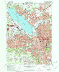
1973 Map of Syracuse West
USGS Topo · Published 1979About this map
Onondaga Lake serves as the central anchor for this urban and suburban landscape, which by the early 1970s shows a dense network of transit and industry. The industrial footprint of Solvay is prominent along the southwestern shore, while the northern banks feature the extensive Onondaga Lake Park and the settlement of Liverpool. The map reveals the expansion of postwar suburbs in Fairmount and Westvale, contrasted with the heavy infrastructure of the New York State Thruway and the Barge Canal terminal.
Find a feature on this map
88 named features on this map. Tap any name to fly to it.
Don’t see what you’re looking for? This feature index may not catch every label — zoom into the map to look around manually.
Map Details
Editions of this 1973 Syracuse West Map
2 editions found
Other maps of this area

1895 · Syracuse
USGS Topo · 1:62,500

1898 · Syracuse
USGS Topo · 1:62,500

1899 · Skaneateles
USGS Topo · 1:62,500

1900 · Baldwinsville
USGS Topo · 1:62,500

1900 · Tully
USGS Topo · 1:62,500

1902 · Skaneateles
USGS Topo · 1:62,500

1938 · Syracuse East
USGS Topo · 1:24,000

1939 · Syracuse West
USGS Topo · 1:24,000

1940 · Brewerton
USGS Topo · 1:24,000

1940 · Cicero
USGS Topo · 1:24,000