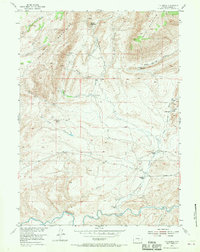
1953 Map of T E Ranch
USGS Topo · Published 1970About this map
The Shirley Mountains and Bald Mountain dominate the northern terrain of this Carbon County region, giving way to a network of creeks and draws that feed the Medicine Bow River at the southern edge. The landscape is defined by its ranching history, with established operations such as the T E Ranch, Walgreen Ranch, and Campbell Ranch situated along the watercourses. Smaller outposts like the Maynard Homestead and Walsh Ranch dot the higher elevations near Cottonwood Creek and Mud Spring Draw.
Find a feature on this map
24 named features on this map. Tap any name to fly to it.
Don’t see what you’re looking for? This feature index may not catch every label — zoom into the map to look around manually.
Map Details
Editions of this 1953 T E Ranch Map
3 editions found
Other maps of this area

1893 · Fort Steele
USGS Topo · 1:125,000

1914 · Hanna
USGS Topo · 1:62,500

1914 · Saddleback Hills
USGS Topo · 1:62,500

1921 · Saddleback Hills
USGS Topo · 1:62,500

1953 · Schneider Ridge
USGS Topo · 1:24,000

1953 · The Q Ranch
USGS Topo · 1:24,000

1953 · T E Ranch
USGS Topo · 1:24,000

1953 · Beaver Creek
USGS Topo · 1:24,000

1954 · Rawlins
USGS Topo · 1:250,000

1955 · Casper
USGS Topo · 1:250,000