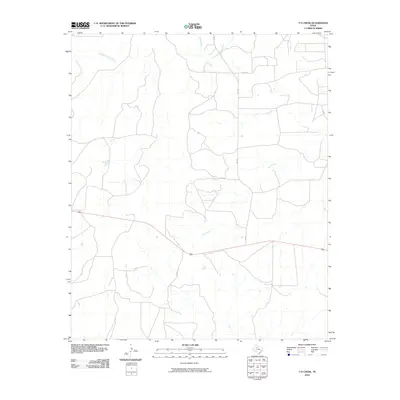
2010 Map of T-O Creek
USGS Topo · Published 2010About this map
The Salt Fork Brazos River winds through the northern reaches of this Kent County landscape, joined by the White River in a region defined by its complex drainage network. This 2010 survey illustrates a sparsely populated ranching or agricultural area where the namesake T-O Creek and Salt Creek carve distinct paths through the terrain. The human imprint is characterized primarily by a grid of rural transit, including FM 1081 and several county roads such as Co Rd 317 and Co Rd 222. The lack of dense town centers emphasizes the vast, open nature of this West Texas territory, where geographic orientation relies on these intermittent watercourses and the established road system that connects remote homesteads and grazing lands.
Find a feature on this map
8 named features on this map. Tap any name to fly to it.
Don’t see what you’re looking for? This feature index may not catch every label — zoom into the map to look around manually.
Map Details
Editions of this 2010 T-O Creek Map
This is the sole edition of this map. No revisions or reprints were ever made.
Other maps of this area

1954 · Lubbock
USGS Topo · 1:250,000

1962 · Twomile Creek
USGS Topo · 1:24,000

1968 · Spur SW
USGS Topo · 1:24,000

1968 · White Camp
USGS Topo · 1:24,000

1969 · Cottonwood Creek
USGS Topo · 1:24,000

1969 · Justiceburg SE
USGS Topo · 1:24,000

1969 · Cooper Mountain
USGS Topo · 1:24,000

1969 · Clairemont West
USGS Topo · 1:24,000

1969 · T-O Creek
USGS Topo · 1:24,000
1969 · Polar
USGS Topo · 1:24,000