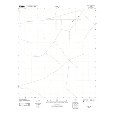
2010 Map of T P Well
USGS Topo · Published 2010About this map
Cottonwood Lake and a series of water catchment features define this arid stretch of El Paso County, where cattle ranching and infrastructure dominate the desert landscape. The map shows a region shaped by the practical needs of the high desert, evidenced by Willow Tanks and Hideaway Tank situated to capture seasonal runoff. Modern industry is represented by the long, straight trajectory of the El Paso Jal Pipeline Rd, which cuts across the northern terrain. Drainage is marked primarily by Borrego Draw, a major natural feature that channels water through this vast open country. For researchers, the map provides a precise look at the 2010 distribution of water sources and maintenance routes essential to local operations in this corner of the state.
Find a feature on this map
5 named features on this map. Tap any name to fly to it.
Don’t see what you’re looking for? This feature index may not catch every label — zoom into the map to look around manually.
Map Details
Editions of this 2010 T P Well Map
This is the sole edition of this map. No revisions or reprints were ever made.
Other maps of this area

1894 · Fort Hancock
USGS Topo · 1:125,000

1896 · El Paso
USGS Topo · 1:125,000

1896 · Rio Grande
USGS Topo · 1:125,000

1903 · Cerro Alto
USGS Topo · 1:125,000

1908 · El Paso
USGS Topo · 1:125,000

1941 · Clint
USGS Topo · 1:62,500

1941 · Tornillo
USGS Topo · 1:62,500

1942 · Borrego
USGS Topo · 1:62,500

1943 · Fort Hancock
USGS Topo · 1:62,500
1945 · Clint
USGS Topo · 1:62,500