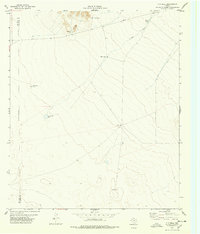
1978 Map of T P Well
USGS Topo · Published 1978About this map
Water resources and land management take center stage in this high-desert region of the Trans-Pecos. The landscape is defined by the vital presence of isolated water sources, including T P Well, Indian Well, and Wheeler Well, which served as critical infrastructure for cattle ranching. This desert topography, surveyed in the mid-1970s, features numerous artificial catchments like New Tank, Willow Tanks, and Hideaway Tank designed to capture ephemeral runoff across the arid flats. The map also records the Indefinite Boundary between El Paso and Hudspeth counties, reflecting the complex surveying history of the West Texas frontier. Industrial activity is visible in the north near the hills, where a Quarry and Gravel Pit indicate local resource extraction. Throughout the quadrangle, a network of fence lines and a Private road suggest a landscape of large, privately held ranching tracts typical of the region.
Find a feature on this map
13 named features on this map. Tap any name to fly to it.
Don’t see what you’re looking for? This feature index may not catch every label — zoom into the map to look around manually.
Map Details
Editions of this 1978 T P Well Map
This is the sole edition of this map. No revisions or reprints were ever made.
Other maps of this area

1894 · Fort Hancock
USGS Topo · 1:125,000

1896 · El Paso
USGS Topo · 1:125,000

1896 · Rio Grande
USGS Topo · 1:125,000

1903 · Cerro Alto
USGS Topo · 1:125,000

1908 · El Paso
USGS Topo · 1:125,000

1941 · Clint
USGS Topo · 1:62,500

1941 · Tornillo
USGS Topo · 1:62,500

1942 · Borrego
USGS Topo · 1:62,500

1943 · Fort Hancock
USGS Topo · 1:62,500
1945 · Clint
USGS Topo · 1:62,500