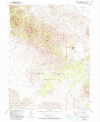
1955 Map of Tabbys Peak SW
USGS Topo · Published 1993About this map
The Dugway Proving Ground (Restricted Area) dominates the southern half of this landscape, marking a stark division between military operations and the natural water sources of the high desert. To the north, the Cedar Mountains provide a series of critical watering points including Cane Springs, Orr Springs, and Bitter Spring, which have long served as essential landmarks in this arid environment. The topography shifts dramatically from the mountain peaks down into Skull Valley and the expansive Sand Dunes near the Alkali Flat. This survey, revised through the late 1980s, documents the 4WD trails and unimproved roads connecting geological features like White Rock and Wide Hollow. A lone Gravel Pit represents the limited industrial footprint outside the restricted military zone.
Find a feature on this map
16 named features on this map. Tap any name to fly to it.
Don’t see what you’re looking for? This feature index may not catch every label — zoom into the map to look around manually.
Map Details
Editions of this 1955 Tabbys Peak SW Map
4 editions found
Other maps of this area

1885 · Tooele Valley
USGS Topo · 1:250,000

1953 · Tooele
USGS Topo · 1:250,000

1954 · Dugway Proving Ground NE
USGS Topo · 1:24,000

1954 · Camels Back Ridge NW
USGS Topo · 1:24,000

1955 · Tabbys Peak SE
USGS Topo · 1:24,000

1955 · Tabbys Peak
USGS Topo · 1:24,000

1955 · Camels Back Ridge NE
USGS Topo · 1:24,000

1955 · Wig Mtn
USGS Topo · 1:24,000

1955 · Wig Mtn NE
USGS Topo · 1:24,000

1955 · Tabbys Peak SW
USGS Topo · 1:24,000