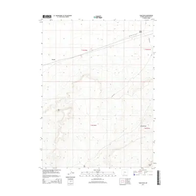
2015 Map of Table Rock
USGS Topo · Published 2015About this map
Table Rock defines the high-desert character of this Sweetwater County landscape, serving as both a prominent geological landmark and the site of a small high-plains settlement. The map reveals a specialized industrial and transit environment, dominated by energy infrastructure such as the Table Rock Gas Plant Rd. While the northern section contains the concentrated developments of Monell and Table Rock, the southern half of the quadrangle transitions into a more isolated drainage basin. Here, the ephemeral Red Wash winds toward the dramatic escarpment of Delaney Rim, which cuts across the southeastern corner. This survey documents a contemporary intersection of Wyoming's energy sector and its characteristic sagebrush-and-rimrock topography, notably at the highway-and-haul-road meeting point of J O Junction.
Find a feature on this map
14 named features on this map. Tap any name to fly to it.
Don’t see what you’re looking for? This feature index may not catch every label — zoom into the map to look around manually.
Map Details
Editions of this 2015 Table Rock Map
This is the sole edition of this map. No revisions or reprints were ever made.
Other maps of this area

1954 · Rock Springs
USGS Topo · 1:250,000

1958 · Rock Springs
USGS Topo · 1:250,000

1962 · Rock Springs
USGS Topo · 1:250,000

1968 · Bitter Creek
USGS Topo · 1:24,000
1968 · Antelope Flats
USGS Topo · 1:24,000

1968 · Bitter Creek NE
USGS Topo · 1:24,000

1970 · Table Rock
USGS Topo · 1:24,000

1970 · J O Dugway
USGS Topo · 1:24,000

1970 · Fort La Clede NE
USGS Topo · 1:24,000

1970 · Tipton
USGS Topo · 1:24,000