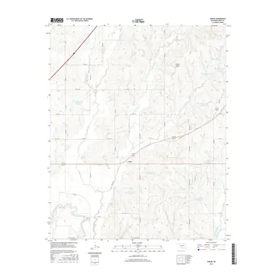
2016 Map of Tabler
USGS Topo · Published 2016About this map
The small community of Tabler serves as the central hub of this Grady County landscape, situated at the intersection of State Hwy 9 and local routes like Lucille Rd. The terrain is defined by a dense network of managed water resources, most notably a series of flood control structures along Bitter Creek and its tributaries, including Bitter Cr Site 20 Reservoir and Bitter Cr Site 14 Reservoir. To the south, the Washita River meanders across the bottomlands, fed by drainage from West Winter Creek and East Winter Creek. This 2016 survey captures the rural character of the region, where family ranching operations like the Good Life Ranch Airport exist alongside a precise grid of section-line roads such as Maple Rd and Ballard Rd. The map illustrates how modern water management has shaped the Oklahoma prairie, creating numerous small reservoirs to stabilize the local watershed.
Find a feature on this map
49 named features on this map. Tap any name to fly to it.
Don’t see what you’re looking for? This feature index may not catch every label — zoom into the map to look around manually.
Map Details
Editions of this 2016 Tabler Map
This is the sole edition of this map. No revisions or reprints were ever made.
Other maps of this area

1902 · Rush Springs
USGS Topo · 1:125,000

1904 · Chickasha
USGS Topo · 1:125,000

1949 · Rush Springs
USGS Topo · 1:62,500

1950 · Rush Springs
USGS Topo · 1:62,500

1954 · Oklahoma City
USGS Topo · 1:250,000

1957 · Ardmore
USGS Topo · 1:250,000

1957 · Oklahoma City
USGS Topo · 1:250,000

1963 · Ardmore
USGS Topo · 1:250,000

1963 · Oklahoma City
USGS Topo · 1:250,000
1965 · Dibble
USGS Topo · 1:24,000