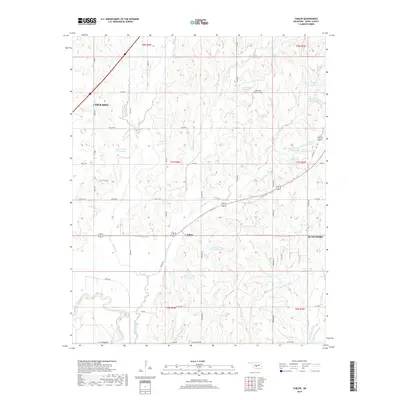
2018 Map of Tabler
USGS Topo · Published 2018About this map
Tabler sits at the center of this Oklahoma landscape, where the agricultural plains of Grady County meet a complex network of managed waterways. This 2018 survey documents a region defined by extensive soil and water conservation efforts, evidenced by a series of numbered reservoirs including Bitter Cr Site 1 Reservoir and Bitter Cr Site 21 Reservoir along the branches of Bitter Creek. To the west, the city of Chickasha extends into the quadrangle, while the eastern edge reaches toward Blanchard. The southern portion of the map is dominated by the winding course of the Washita River and its confluence with Bitter Creek, alongside the seasonal flows of West Winter Creek and East Winter Creek. A notable landmark for local aviation is the Good Life Ranch Airport, located north of Spring Cr. The map provides a detailed view of the rural section-line road system that organizes the modern Oklahoma countryside.
Find a feature on this map
56 named features on this map. Tap any name to fly to it.
Don’t see what you’re looking for? This feature index may not catch every label — zoom into the map to look around manually.
Map Details
Editions of this 2018 Tabler Map
This is the sole edition of this map. No revisions or reprints were ever made.
Other maps of this area

1902 · Rush Springs
USGS Topo · 1:125,000

1904 · Chickasha
USGS Topo · 1:125,000

1949 · Rush Springs
USGS Topo · 1:62,500

1950 · Rush Springs
USGS Topo · 1:62,500

1954 · Oklahoma City
USGS Topo · 1:250,000

1957 · Ardmore
USGS Topo · 1:250,000

1957 · Oklahoma City
USGS Topo · 1:250,000

1963 · Ardmore
USGS Topo · 1:250,000

1963 · Oklahoma City
USGS Topo · 1:250,000
1965 · Dibble
USGS Topo · 1:24,000