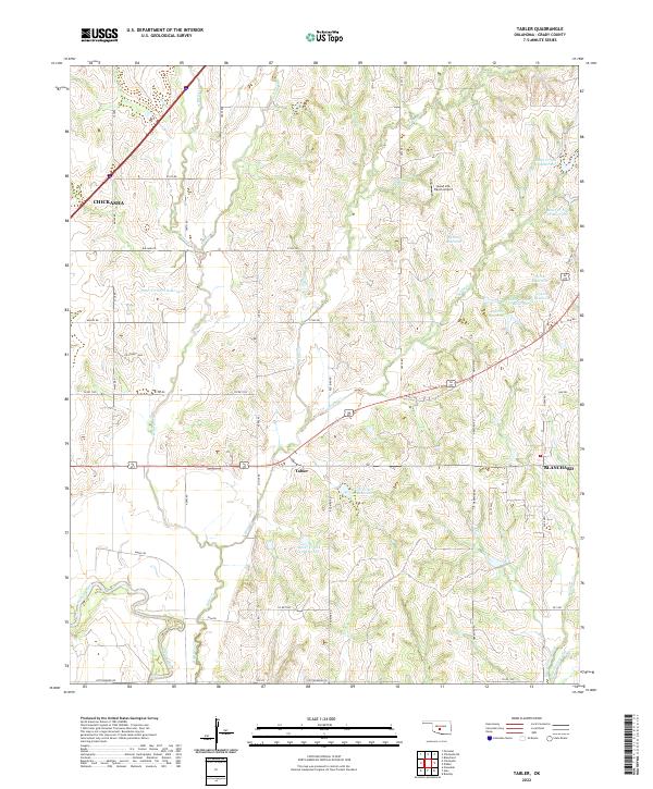
2022 Map of Tabler
USGS Topo · Published 2022About this map
The settlement of Tabler serves as a central hub in this section of Grady County, surrounded by a complex network of agricultural roads and drainage systems. This landscape is defined by the branching tributaries of Bitter Cr and Spring Cr, which feed into the Washita River in the southwestern corner. The mapping shows an extensive series of flood control structures, including named reservoirs like Bitter Creek Site 1 Reservoir and Bitter Creek Site 20 Reservoir. In the northeast, the Good Life Ranch Airport stands as a private aviation landmark among the hills. The map captures the periphery of larger towns, with Chickasha appearing to the northwest and Blanchard to the east, illustrating the rural-to-suburban transition of the modern era. The intricate terrain of West Winter Creek and East Winter Creek in the southeast highlights the rugged creek valleys common to this part of Oklahoma.
Find a feature on this map
61 named features on this map. Tap any name to fly to it.
Don’t see what you’re looking for? This feature index may not catch every label — zoom into the map to look around manually.
Map Details
Editions of this 2022 Tabler Map
This is the sole edition of this map. No revisions or reprints were ever made.
Other maps of this area

1902 · Rush Springs
USGS Topo · 1:125,000

1904 · Chickasha
USGS Topo · 1:125,000

1949 · Rush Springs
USGS Topo · 1:62,500

1950 · Rush Springs
USGS Topo · 1:62,500

1954 · Oklahoma City
USGS Topo · 1:250,000

1957 · Ardmore
USGS Topo · 1:250,000

1957 · Oklahoma City
USGS Topo · 1:250,000

1963 · Ardmore
USGS Topo · 1:250,000

1963 · Oklahoma City
USGS Topo · 1:250,000
1965 · Dibble
USGS Topo · 1:24,000