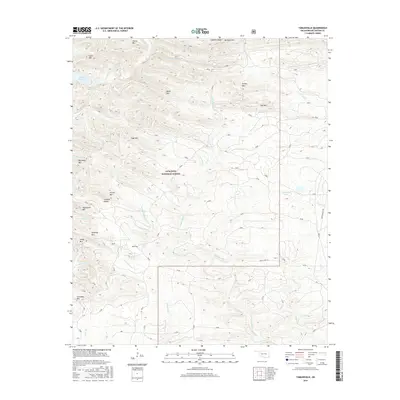
2016 Map of Tablerville
USGS Topo · Published 2016About this map
The Ouachita National Forest covers much of this McCurtain County landscape, where the terrain is defined by a dense network of ridges and creek drainages. The small settlement of Tablerville is positioned south of the W Fork Middle Rock Cr, surrounded by prominent peaks such as Sage Mtn, Kennedy Mtn, and Carnasaw Mtn. Waterways are a central feature of the topography, including the upper reaches of Broken Bow Lake and the winding paths of Liksuklo Cr and Middle Rock Cr. The map details the transition from high points like Williams Mtn and Turkey Mtn down into the narrow valleys. This area reflects a landscape largely preserved for timber and recreation, with named locations like Fivemile Hollow and Gobblers Knob indicating the long-standing local nomenclature used by residents and forest managers alike.
Find a feature on this map
36 named features on this map. Tap any name to fly to it.
Don’t see what you’re looking for? This feature index may not catch every label — zoom into the map to look around manually.
Map Details
Editions of this 2016 Tablerville Map
This is the sole edition of this map. No revisions or reprints were ever made.
Other maps of this area

1902 · Lukfata
USGS Topo · 1:125,000

1913 · De Queen
USGS Topo · 1:125,000

1950 · Mcalester
USGS Topo · 1:250,000

1959 · Cove
USGS Topo · 1:62,500

1959 · Broken Bow
USGS Topo · 1:62,500

1960 · Smithville
USGS Topo · 1:62,500

1962 · McAlester
USGS Topo · 1:250,000

1965 · McAlester
USGS Topo · 1:250,000
1965 · Chapel Hill
USGS Topo · 1:24,000
1966 · De Queen NW
USGS Topo · 1:24,000