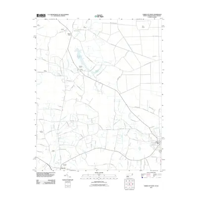
2011 Map of Tabor City West
USGS Topo · Published 2011About this map
Tory Island and the complex wetlands of Gapway Swamp define the borderlands between North and South Carolina in this 2011 survey. The landscape is characterized by a high concentration of family and community burial grounds, such as Lovett Cemetery, Blanton Cemetery, and Green Sea Cemetery, which offer significant value for genealogical research in this rural corridor. Small settlements like Cherry Grove and Green Sea anchor the region, connected by a network of local roads including Fair Bluff Hwy and Sidney Cherry Grove Rd. The presence of the Turbeville Airport near Richardson Pond indicates the localized infrastructure serving these communities. This map documents the hydrologic patterns of the coastal plain, tracing numerous branches such as Crooked Run Branch and Mill Branch as they wind through the agricultural and swampy terrain.
Find a feature on this map
109 named features on this map. Tap any name to fly to it.
Don’t see what you’re looking for? This feature index may not catch every label — zoom into the map to look around manually.
Map Details
Editions of this 2011 Tabor City West Map
This is the sole edition of this map. No revisions or reprints were ever made.
Other maps of this area

1943 · Pages Mill
USGS Topo · 1:62,500

1948 · Bayboro
USGS Topo · 1:24,000

1949 · Bayboro
USGS Topo · 1:24,000

1949 · Duford
USGS Topo · 1:24,000

1953 · Chadbourn
USGS Topo · 1:62,500

1953 · Florence
USGS Topo · 1:250,000

1954 · Florence
USGS Topo · 1:250,000
1962 · Loris
USGS Topo · 1:24,000

1962 · Fair Bluff
USGS Topo · 1:24,000
1962 · Goretown
USGS Topo · 1:24,000