
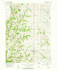
1957 Map of Tabor
USGS Topo · Published 1958About this map
Tabor sits at the southern edge of this mid-century landscape, positioned on the boundary of Mills and Fremont counties. The map documents a rural transition as several local schoolhouses, including Pleasant Ridge Sch, Four Corners Sch, and Elm Grove Sch, are noted as abandoned. This suggests the consolidation of rural education during the 1950s, leaving only the town centers and family cemeteries to mark the legacy of earlier settlement patterns.
Find a feature on this map
24 named features on this map. Tap any name to fly to it.
Don’t see what you’re looking for? This feature index may not catch every label — zoom into the map to look around manually.
Map Details
Editions of this 1957 Tabor Map
2 editions found
Other maps of this area

1935 · Nehawka
USGS Topo · 1:48,000

1940 · Nehawka
USGS Topo · 1:62,500

1954 · Omaha
USGS Topo · 1:250,000

1955 · Nebraska City
USGS Topo · 1:250,000

1956 · Glenwood
USGS Topo · 1:24,000

1956 · Rock Bluff
USGS Topo · 1:24,000

1956 · Pacific Junction
USGS Topo · 1:24,000

1956 · Malvern
USGS Topo · 1:24,000

1957 · Nebraska City
USGS Topo · 1:250,000

1957 · Omaha
USGS Topo · 1:250,000