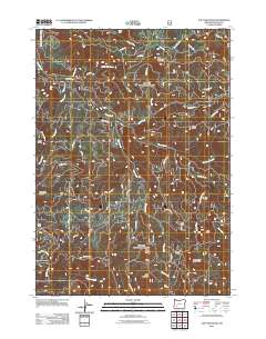
2011 Map of Taft Mountain
USGS Topo · Published 2011About this map
Taft Mountain and the surrounding high country of the Umpqua National Forest are defined by a complex network of drainage basins and ridges in this 2011 survey. The Little River and its numerous tributaries, including White Creek and Black Creek, carve through the landscape, creating distinct landforms like Clover Ridge and Taft Ridge. The presence of Camp Grant and the Sunset Shelter indicates the long-standing recreational and management infrastructure within these timberlands.
Find a feature on this map
52 named features on this map. Tap any name to fly to it.
Don’t see what you’re looking for? This feature index may not catch every label — zoom into the map to look around manually.
Map Details
Editions of this 2011 Taft Mountain Map
This is the sole edition of this map. No revisions or reprints were ever made.
Other maps of this area

1955 · Quartz Mtn
USGS Topo · 1:62,500

1955 · Red Butte
USGS Topo · 1:62,500

1955 · Mace Mtn
USGS Topo · 1:62,500

1955 · Illahee Rock
USGS Topo · 1:62,500

1958 · Roseburg
USGS Topo · 1:250,000

1959 · Roseburg
USGS Topo · 1:250,000

1978 · Diamond Lake
USGS Topo · 1:100,000
1989 · Acker Rock
USGS Topo · 1:24,000
1989 · Taft Mountain
USGS Topo · 1:24,000
1989 · Old Fairview
USGS Topo · 1:24,000