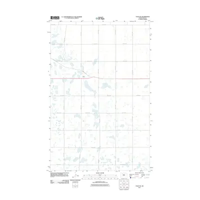
2011 Map of Tagus SE
USGS Topo · Published 2011About this map
Roach Siding stands as a primary landmark in this section of Ward County, situated along the railroad tracks that cut diagonally across the northern landscape. This 2011 survey reveals a classic prairie grid system defined by rural routes like 128th Ave NW and 366th St NW, which segment the terrain into a sprawling network of agricultural parcels. The landscape is heavily dotted with small, scattered wetlands and prairie potholes, a characteristic trait of the North Dakota drift plain. Significant regional transit is facilitated by County Hwy 5W, which intersects the rail line near the siding. The map provides a detailed view of the infrastructure supporting this rural economy, from the section-line roads like 46th Ave NW to the drainage patterns that define the local topography.
Find a feature on this map
15 named features on this map. Tap any name to fly to it.
Don’t see what you’re looking for? This feature index may not catch every label — zoom into the map to look around manually.
Map Details
Editions of this 2011 Tagus SE Map
This is the sole edition of this map. No revisions or reprints were ever made.
Other maps of this area

1949 · Hartland
USGS Topo · 1:24,000

1949 · Carpio
USGS Topo · 1:24,000

1954 · Minot
USGS Topo · 1:250,000

1958 · Minot
USGS Topo · 1:250,000

1980 · Minot
USGS Topo · 1:100,000

1980 · Rice Lake NW
USGS Topo · 1:24,000

1980 · Tagus SE
USGS Topo · 1:24,000
1980 · Berthold
USGS Topo · 1:24,000
1980 · Aurelia
USGS Topo · 1:24,000

1980 · Tagus
USGS Topo · 1:24,000