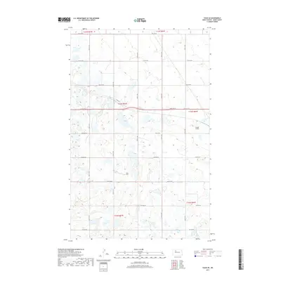
2017 Map of Tagus SE
USGS Topo · Published 2017About this map
Arnold Coulee cuts through the northeast corner of this Ward County landscape, characterizing the glacial drainage patterns typical of this North Dakota region. The map reveals a highly structured section-line road network, where routes like 128th Ave NW and 366th St NW define the boundaries of agricultural operations and local landholdings. A noteworthy landmark is the Berg Strip, an aviation feature situated among the numerous small wetlands and prairie potholes that dot the township divisions.
Find a feature on this map
23 named features on this map. Tap any name to fly to it.
Don’t see what you’re looking for? This feature index may not catch every label — zoom into the map to look around manually.
Map Details
Editions of this 2017 Tagus SE Map
This is the sole edition of this map. No revisions or reprints were ever made.
Other maps of this area

1949 · Hartland
USGS Topo · 1:24,000

1949 · Carpio
USGS Topo · 1:24,000

1954 · Minot
USGS Topo · 1:250,000

1958 · Minot
USGS Topo · 1:250,000

1980 · Minot
USGS Topo · 1:100,000

1980 · Rice Lake NW
USGS Topo · 1:24,000

1980 · Tagus SE
USGS Topo · 1:24,000
1980 · Berthold
USGS Topo · 1:24,000
1980 · Aurelia
USGS Topo · 1:24,000

1980 · Tagus
USGS Topo · 1:24,000