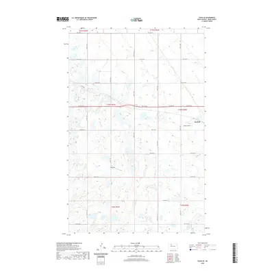
2020 Map of Tagus SE
USGS Topo · Published 2020About this map
Berthold anchors the eastern edge of this landscape in Ward County, situated near the headwaters of Arnold Coulee. This 2020 topographic study illustrates the transition from the rolling prairie into the coulee's drainage patterns, which are etched across the northern sections of the map. The township and range lines of the Public Land Survey System divide the terrain into a rhythmic grid of section roads, including 128th Ave NW and Co Rd 5W, typical of the rural North Dakota wheat belt.
Find a feature on this map
24 named features on this map. Tap any name to fly to it.
Don’t see what you’re looking for? This feature index may not catch every label — zoom into the map to look around manually.
Map Details
Editions of this 2020 Tagus SE Map
This is the sole edition of this map. No revisions or reprints were ever made.
Other maps of this area

1949 · Hartland
USGS Topo · 1:24,000

1949 · Carpio
USGS Topo · 1:24,000

1954 · Minot
USGS Topo · 1:250,000

1958 · Minot
USGS Topo · 1:250,000

1980 · Minot
USGS Topo · 1:100,000

1980 · Rice Lake NW
USGS Topo · 1:24,000

1980 · Tagus SE
USGS Topo · 1:24,000
1980 · Berthold
USGS Topo · 1:24,000
1980 · Aurelia
USGS Topo · 1:24,000

1980 · Tagus
USGS Topo · 1:24,000