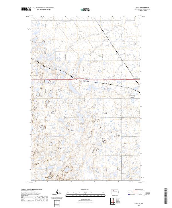
2024 Map of Tagus SE
USGS Topo · Published 2024About this map
Glacial potholes and prairie wetlands dominate this Ward County landscape, where the Ward County Waterfowl Production Area preserves a significant portion of the natural terrain. The map captures the highly organized section-line road network typical of North Dakota, with routes like 86th Ave NW and 324th St NW forming a grid across the undulating topography. In the east, Arnold Coulee provides a rare break in the terrain, carved by drainage toward the nearby town of Berthold. The inclusion of the Berg Strip airfield among the clusters of small lakes and marshes reflects the intersection of agricultural utility and aviation in this sparsely populated region. This survey illustrates the persistence of the 19th-century Public Land Survey System, with township boundaries such as t156n r87w clearly delineated across the prairie.
Find a feature on this map
26 named features on this map. Tap any name to fly to it.
Don’t see what you’re looking for? This feature index may not catch every label — zoom into the map to look around manually.
Map Details
Editions of this 2024 Tagus SE Map
This is the sole edition of this map. No revisions or reprints were ever made.
Other maps of this area

1949 · Hartland
USGS Topo · 1:24,000

1949 · Carpio
USGS Topo · 1:24,000

1954 · Minot
USGS Topo · 1:250,000

1958 · Minot
USGS Topo · 1:250,000

1980 · Minot
USGS Topo · 1:100,000

1980 · Rice Lake NW
USGS Topo · 1:24,000

1980 · Tagus SE
USGS Topo · 1:24,000
1980 · Berthold
USGS Topo · 1:24,000
1980 · Aurelia
USGS Topo · 1:24,000

1980 · Tagus
USGS Topo · 1:24,000