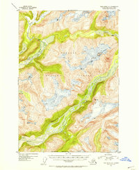
1951 Map of Taku River A-5
USGS Topo · Published 1954About this map
The Tongass National Forest dominates this glacial landscape, characterized by dramatic ice fields and braided river systems. The Whiting River and Speel River carve through the terrain, featuring multiple rapids and expansive gravel bars that shift with the seasons. Several prominent peaks serve as aerial survey benchmarks, including Snow Tower and VABM 5225 Frosty, providing essential elevation data for this coastal wilderness. The distribution of alpine lakes like Tease Lake and Crescent Lake high above the river valleys illustrates the complex hydrological patterns of the region. These features, along with coastal markers like Whiting Point and Ox Point, highlight a rugged environment where navigation was dictated by the movement of ice and the flow of glacial meltwater.
Find a feature on this map
18 named features on this map. Tap any name to fly to it.
Don’t see what you’re looking for? This feature index may not catch every label — zoom into the map to look around manually.
Map Details
Editions of this 1951 Taku River A-5 Map
4 editions found
Other maps of this area

1948 · Sumdum D-6
USGS Topo · 1:63,360

1948 · Sumdum D-5
USGS Topo · 1:63,360

1951 · Taku River A-4
USGS Topo · 1:63,360

1951 · Taku River B-6
USGS Topo · 1:63,360

1951 · Taku River A-5
USGS Topo · 1:63,360

1951 · Taku River A-6
USGS Topo · 1:63,360

1951 · Taku River B-5
USGS Topo · 1:63,360

1951 · Sumdum D-6
USGS Topo · 1:63,360

1952 · Sumdum
USGS Topo · 1:250,000

1953 · Taku River
USGS Topo · 1:250,000