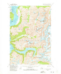
1951 Map of Taku River B-6
USGS Topo · Published 1972About this map
Taku Lodge and the adjacent Customhouse sit at the edge of the Taku River, serving as a remote outpost in the early 1950s within the Tongass National Forest. This survey captures a landscape dominated by massive ice and water systems, where a Seaplane Base provides essential access to the interior. The glacial activity is prominent, with the Hole-in-the-Wall Glacier feeding into the river and Bridge Glacier carving through the high peaks to the east.
Find a feature on this map
21 named features on this map. Tap any name to fly to it.
Don’t see what you’re looking for? This feature index may not catch every label — zoom into the map to look around manually.
Map Details
Editions of this 1951 Taku River B-6 Map
4 editions found
Other maps of this area

1948 · Juneau B-1
USGS Topo · 1:63,360

1951 · Juneau
USGS Topo · 1:250,000

1951 · Taku River B-6
USGS Topo · 1:63,360

1951 · Taku River A-5
USGS Topo · 1:63,360

1951 · Taku River A-6
USGS Topo · 1:63,360

1951 · Taku River B-5
USGS Topo · 1:63,360

1951 · Juneau A-1
USGS Topo · 1:63,360

1952 · Juneau B-1
USGS Topo · 1:63,360

1953 · Taku River
USGS Topo · 1:250,000

1954 · Juneau A-1
USGS Topo · 1:63,360