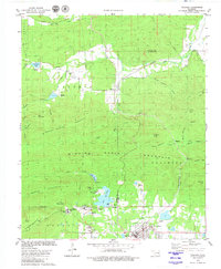
1979 Map of Talihina
USGS Topo · Published 1980About this map
Talihina serves as the primary hub at the base of the Winding Stair Mountain range, where the valley floor transitions into the sharp ridges of the Ouachita Mountains. The presence of the US Government Hospital and the State Veterans Center on the southern outskirts of town highlights the community's role as a regional center for healthcare and public service. Transportation through this varied terrain is anchored by the St Louis-San Francisco railroad, which follows the natural contours of the land past Lake Carl Albert and through the gap between mountains. To the north, smaller settlements like Bengal and Compton are tucked into the valleys, while family-named landmarks such as the Peachland Cem and Peachland Creek reflect the area's rural genealogy and long-standing local ties.
Find a feature on this map
43 named features on this map. Tap any name to fly to it.
Don’t see what you’re looking for? This feature index may not catch every label — zoom into the map to look around manually.
Map Details
Editions of this 1979 Talihina Map
This is the sole edition of this map. No revisions or reprints were ever made.
Other maps of this area

1900 · Winding Stair
USGS Topo · 1:125,000

1901 · Tuskahoma
USGS Topo · 1:125,000

1908 · Tuskahoma
USGS Topo · 1:125,000

1909 · Tuskahoma
USGS Topo · 1:125,000

1909 · Winding Stair
USGS Topo · 1:125,000

1940 · Red Oak
USGS Topo · 1:62,500

1943 · Red Oak
USGS Topo · 1:62,500

1950 · Mcalester
USGS Topo · 1:250,000

1962 · McAlester
USGS Topo · 1:250,000

1965 · McAlester
USGS Topo · 1:250,000