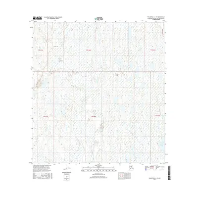
2016 Map of Talkeetna A-1 NW
USGS Topo · Published 2016About this map
Trapper Creek sits at a critical junction in this Matanuska-Susitna landscape, where the vast drainage networks of the Susitna Valley define the local geography. The map illustrates a complex riparian environment characterized by the meandering Moose Creek and Ninemile Creek, which cut through a terrain densely packed with wetlands and small glacial ponds. Transportation in this era is anchored by the Parks Highway running along the eastern edge and the winding Oilwell Road to the west, providing the primary access points for this interior region. Smaller water bodies like Whistling Lake and the cluster of Rockys Lakes offer specific landmarks for local history researchers and those studying the distribution of early 21st-century homesteads and remote outposts. The survey reflects the typical settlement patterns of the Alaskan bush, where human footprints remain secondary to the dominant presence of the Salimilo Creek drainage and its surrounding marshes.
Find a feature on this map
14 named features on this map. Tap any name to fly to it.
Don’t see what you’re looking for? This feature index may not catch every label — zoom into the map to look around manually.
Map Details
Editions of this 2016 Talkeetna A-1 NW Map
This is the sole edition of this map. No revisions or reprints were ever made.
Other maps of this area

1950 · Talkeetna
USGS Topo · 1:250,000

1951 · Talkeetna
USGS Topo · 1:250,000

1951 · Talkeetna B-1
USGS Topo · 1:63,360

1952 · Talkeetna A-1
USGS Topo · 1:63,360

1954 · Talkeetna A-2
USGS Topo · 1:63,360

1954 · Talkeetna B-2
USGS Topo · 1:63,360

1958 · Talkeetna B-1
USGS Topo · 1:63,360
1958 · Talkeetna A-1
USGS Topo · 1:63,360

1958 · Talkeetna
USGS Topo · 1:250,000

1965 · Talkeetna
USGS Topo · 1:250,000