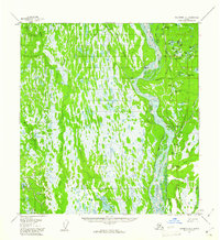
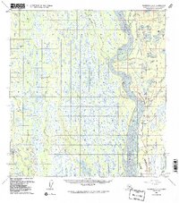
1958 Map of Talkeetna A-1
USGS Topo · Published 1961About this map
The Susitna River carves a complex, braided path through this 1958 landscape, defining the primary corridor for transportation and settlement in the region. Along its eastern banks, the Alaska Railroad serves the small outposts of Montana and Sunshine, where the rail line and a local airstrip facilitated movement across the marshy interior. The map reveals a dense network of water features, from the large Trapper Lake in the south to the intricate Birch Creek Slough and the Sunshine Lakes further north. Inland, the presence of a Tractor Trail crossing Quaker Creek and Rabideux Creek suggests the seasonal nature of land travel before established roads reached this part of the Susitna Valley. The western edge of the sheet is dominated by the broad Kahiltna River, highlighting the vast glacial drainage systems that characterize this part of Alaska.
Find a feature on this map
40 named features on this map. Tap any name to fly to it.
Don’t see what you’re looking for? This feature index may not catch every label — zoom into the map to look around manually.
Map Details
Editions of this 1958 Talkeetna A-1 Map
5 editions found
Other maps of this area

1949 · Tyonek
USGS Topo · 1:250,000

1949 · Talkeetna Mountains B-6
USGS Topo · 1:63,360

1949 · Anchorage D-8
USGS Topo · 1:63,360

1950 · Talkeetna Mountains
USGS Topo · 1:250,000

1950 · Talkeetna
USGS Topo · 1:250,000

1950 · Talkeetna Mountains A-6
USGS Topo · 1:63,360

1951 · Talkeetna
USGS Topo · 1:250,000

1951 · Talkeetna B-1
USGS Topo · 1:63,360

1951 · Anchorage
USGS Topo · 1:250,000

1951 · Tyonek
USGS Topo · 1:250,000