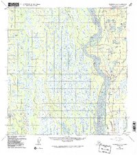
1958 Map of Talkeetna A-1
USGS Topo · Published 1987About this map
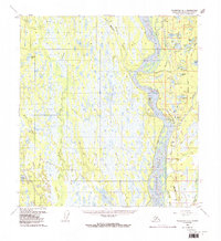
The Susitna River dominates this mid-century Alaskan landscape, its braided channels and islands creating a complex riparian system through the Susitna Valley. Following the river's eastern bank, the Alaska Railroad and the Parks Highway serve as the primary transport arteries, connecting small trackside points like Sunshine and Montana. The map reveals a transition in infrastructure, showing the Talkeetna Road and several segments of Winter Trail used for seasonal movement through the wetlands. A notable concentration of small, numbered lakes—from Lake One to Lake Six—sits north of the Answer Creek drainage. Further west, the terrain becomes a dense network of muskeg and water bodies such as Trapper Lake and the Rocky Lakes, highlighting the challenging environment for early settlers like those at Parker or the remote cabins scattered along Birch Creek.
Find a feature on this map
60 named features on this map. Tap any name to fly to it.
Don’t see what you’re looking for? This feature index may not catch every label — zoom into the map to look around manually.
Map Details
Editions of this 1958 Talkeetna A-1 Map
5 editions found
Other maps of this area

1949 · Tyonek
USGS Topo · 1:250,000

1949 · Talkeetna Mountains B-6
USGS Topo · 1:63,360

1949 · Anchorage D-8
USGS Topo · 1:63,360

1950 · Talkeetna Mountains
USGS Topo · 1:250,000

1950 · Talkeetna
USGS Topo · 1:250,000

1950 · Talkeetna Mountains A-6
USGS Topo · 1:63,360

1951 · Talkeetna
USGS Topo · 1:250,000

1951 · Talkeetna B-1
USGS Topo · 1:63,360

1951 · Anchorage
USGS Topo · 1:250,000

1951 · Tyonek
USGS Topo · 1:250,000