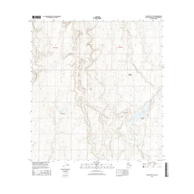
2016 Map of Talkeetna A-2 NE
USGS Topo · Published 2016About this map
Trapper Creek sits at a critical junction of interior access in the Matanuska-Susitna Borough, where the local road network begins to branch into the wilderness. The presence of Oilwell Road and the Trapper Creek Oilwell Road reflects the industrial and resource extraction history of the region, providing vital overland routes through the marshy lowland terrain. These roads cut through a landscape defined by significant water bodies such as Amber Lake and Schnieder Lake, alongside the winding paths of Peters Creek and Kroto Creek. Aviators and local residents rely on landmarks like the Davidson Strip, which serves as a remote landing point in a region where ground transportation remains limited. The map detail shows the transition from the concentrated settlement at Trapper Creek to the more remote sections of t25n r7w and t24n r8w, illustrating the sparse but deliberate footprint of human activity in the Alaskan bush.
Find a feature on this map
14 named features on this map. Tap any name to fly to it.
Don’t see what you’re looking for? This feature index may not catch every label — zoom into the map to look around manually.
Map Details
Editions of this 2016 Talkeetna A-2 NE Map
This is the sole edition of this map. No revisions or reprints were ever made.
Other maps of this area

1950 · Talkeetna
USGS Topo · 1:250,000

1951 · Talkeetna
USGS Topo · 1:250,000

1951 · Talkeetna B-1
USGS Topo · 1:63,360

1952 · Talkeetna A-1
USGS Topo · 1:63,360

1954 · Talkeetna A-2
USGS Topo · 1:63,360

1954 · Talkeetna B-2
USGS Topo · 1:63,360

1958 · Talkeetna B-1
USGS Topo · 1:63,360
1958 · Talkeetna A-1
USGS Topo · 1:63,360

1958 · Talkeetna
USGS Topo · 1:250,000

1965 · Talkeetna
USGS Topo · 1:250,000