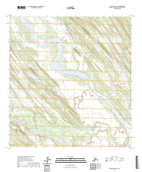
2023 Map of Talkeetna A-4 NE
USGS Topo · Published 2023About this map
The Yentna River flows through this expansive wetland and riverine landscape in the Matanuska-Susitna Borough. The river’s winding course includes a prominent feature at Youngstown Bend, where the waterway creates a large loop through the low-lying terrain. The confluence of several major tributaries, including the Kichatna River and Gagnan Creek, highlights the complex drainage system of this remote Alaskan interior region. Small-scale human presence is recorded near the settlement of Dusdida in the southeastern portion of the map. Elevated landforms are few in this predominantly aquatic environment, though Gold Hill rises above the surrounding marshes and creek beds like Clearwater Creek and Donkey Creek. The map documents a territory defined by seasonal water flow and shifting river channels, critical for understanding the historical geography of these interior Alaskan waterways.
Find a feature on this map
14 named features on this map. Tap any name to fly to it.
Don’t see what you’re looking for? This feature index may not catch every label — zoom into the map to look around manually.
Map Details
Editions of this 2023 Talkeetna A-4 NE Map
This is the sole edition of this map. No revisions or reprints were ever made.
Other maps of this area

1950 · Talkeetna
USGS Topo · 1:250,000

1951 · Talkeetna
USGS Topo · 1:250,000

1954 · Talkeetna A-3
USGS Topo · 1:63,360

1954 · Talkeetna B-4
USGS Topo · 1:63,360

1954 · Talkeetna A-4
USGS Topo · 1:63,360

1954 · Talkeetna B-3
USGS Topo · 1:63,360

1958 · Talkeetna
USGS Topo · 1:250,000

1965 · Talkeetna
USGS Topo · 1:250,000
2013 · Talkeetna B-3 SW
USGS Topo · 1:25,000
2016 · Talkeetna A-3 NW
USGS Topo · 1:25,000