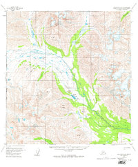
1958 Map of Talkeetna A-6
USGS Topo · Published 1974About this map
Rainy Pass Lodge serves as a remote hub in this subarctic landscape, situated on the shores of Puntilla Lake beneath the shadows of Lookout Hill and Puntilla Mountain. This 1958 survey captures the critical infrastructure of the Alaskan interior during the mid-20th century, noting Radio Towers and a Landing Strip essential for communication and access. The terrain is defined by the braided path of the Happy River and its numerous tributaries, including Squaw Creek and Glacier Creek.
Find a feature on this map
26 named features on this map. Tap any name to fly to it.
Don’t see what you’re looking for? This feature index may not catch every label — zoom into the map to look around manually.
Map Details
Editions of this 1958 Talkeetna A-6 Map
3 editions found
Other maps of this area

1949 · Tyonek
USGS Topo · 1:250,000

1949 · McGrath
USGS Topo · 1:250,000

1950 · McGrath
USGS Topo · 1:250,000

1950 · Talkeetna
USGS Topo · 1:250,000

1951 · Talkeetna
USGS Topo · 1:250,000

1951 · Tyonek
USGS Topo · 1:250,000

1951 · Lime Hills
USGS Topo · 1:250,000

1958 · Talkeetna A-6
USGS Topo · 1:63,360

1958 · Talkeetna A-5
USGS Topo · 1:63,360

1958 · Talkeetna B-5
USGS Topo · 1:63,360