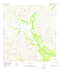
1958 Map of Talkeetna A-6
USGS Topo · Published 1974About this map
Rainy Pass Lodge serves as a primary human outpost in this wilderness area within the Matanuska-Susitna Borough, situated near the shores of Puntilla Lake. The map details a landscape defined by the drainage systems of the Happy River and its various tributaries, including Squaw Creek and Canyon Creek. Transportation is dominated by historic overland routes, most notably the Old Iditarod Trail which follows the river valley, and a Winter Trail that cuts through the mountain passes. The presence of a Landing Strip and Radio Towers near the lodge underscores the importance of bush aviation for accessing this interior terrain. Surrounding peaks such as Puntilla Mountain, Eva Peak, and Round Mountain frame the high-altitude valleys, while smaller water bodies like Moose Creek Lake and Halfway Lake dot the lowlands between the mountain ranges.
Find a feature on this map
32 named features on this map. Tap any name to fly to it.
Don’t see what you’re looking for? This feature index may not catch every label — zoom into the map to look around manually.
Map Details
Editions of this 1958 Talkeetna A-6 Map
3 editions found
Other maps of this area

1949 · Tyonek
USGS Topo · 1:250,000

1949 · McGrath
USGS Topo · 1:250,000

1950 · McGrath
USGS Topo · 1:250,000

1950 · Talkeetna
USGS Topo · 1:250,000

1951 · Talkeetna
USGS Topo · 1:250,000

1951 · Tyonek
USGS Topo · 1:250,000

1951 · Lime Hills
USGS Topo · 1:250,000

1958 · Talkeetna A-6
USGS Topo · 1:63,360

1958 · Talkeetna A-5
USGS Topo · 1:63,360

1958 · Talkeetna B-5
USGS Topo · 1:63,360