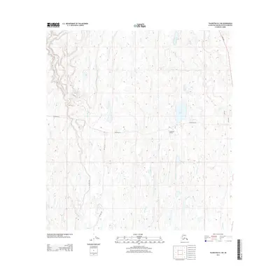
2013 Map of Talkeetna B-1 SW
USGS Topo · Published 2013About this map
Petersville Rd and Oil Well Rd traverse this wetland-rich landscape in the Matanuska-Susitna Borough, revealing a pattern of remote accessibility and resource exploration. The terrain is defined by an intricate network of waterways, including Moose Cr, Sawmill Cr, and the smaller Ninemile Cr, which feed into numerous named bodies of water such as Scotty Lake and Long Lake. The presence of the Rangeview Airstrip alongside Petersville Rd highlights the importance of bush aviation in this part of Alaska, where terrestrial roads like Trail Ridge Rd and Watkins Rd provide the only other links to the more traveled Parks Hwy corridor. This 2013 survey illustrates the careful balance of infrastructure within a landscape dominated by drainage basins like Gate Cr and W Fork Moose Cr, where the vast majority of the land remains undeveloped and centered on these natural water features.
Find a feature on this map
19 named features on this map. Tap any name to fly to it.
Don’t see what you’re looking for? This feature index may not catch every label — zoom into the map to look around manually.
Map Details
Editions of this 2013 Talkeetna B-1 SW Map
This is the sole edition of this map. No revisions or reprints were ever made.
Other maps of this area

1950 · Talkeetna
USGS Topo · 1:250,000

1951 · Talkeetna
USGS Topo · 1:250,000

1951 · Talkeetna B-1
USGS Topo · 1:63,360

1952 · Talkeetna A-1
USGS Topo · 1:63,360

1954 · Talkeetna A-2
USGS Topo · 1:63,360

1954 · Talkeetna B-2
USGS Topo · 1:63,360

1958 · Talkeetna B-1
USGS Topo · 1:63,360
1958 · Talkeetna A-1
USGS Topo · 1:63,360

1958 · Talkeetna
USGS Topo · 1:250,000

1965 · Talkeetna
USGS Topo · 1:250,000