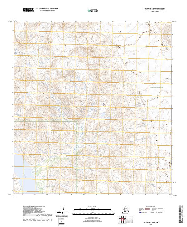
2023 Map of Talkeetna C-3 SW
USGS Topo · Published 2023About this map
Denali National Park encompasses the northeastern portion of this topographic survey, marking a protected transition from the high peaks of the Alaska Range to the complex hydrography of the Matanuska-Susitna region. The southern landscape is dominated by the glacial waters of Chelatna Lake, which feeds into the southward-flowing Lake Creek. Smaller tributaries such as Coffee Creek and Snowslide Creek drain the surrounding elevations, illustrating a classic Alaskan drainage pattern where steep mountain runoff converges into larger lake systems. This 2023 edition provides precise contour data and land boundaries within the t29n r11w and t28n r12w township sections, serving as a modern reference for the enduring wilderness and changing shorelines of these remote waterways.
Find a feature on this map
10 named features on this map. Tap any name to fly to it.
Don’t see what you’re looking for? This feature index may not catch every label — zoom into the map to look around manually.
Map Details
Editions of this 2023 Talkeetna C-3 SW Map
This is the sole edition of this map. No revisions or reprints were ever made.
Other maps of this area

1950 · Talkeetna
USGS Topo · 1:250,000

1951 · Talkeetna
USGS Topo · 1:250,000

1954 · Talkeetna B-4
USGS Topo · 1:63,360

1954 · Talkeetna B-3
USGS Topo · 1:63,360

1958 · Talkeetna C-4
USGS Topo · 1:63,360

1958 · Talkeetna C-3
USGS Topo · 1:63,360

1958 · Talkeetna
USGS Topo · 1:250,000

1965 · Talkeetna
USGS Topo · 1:250,000
2014 · Talkeetna C-3 NW
USGS Topo · 1:25,000
2014 · Talkeetna C-3 NE
USGS Topo · 1:25,000